Ακόμα απρόσιτη η λίμνη Βοστόκ στην Ανταρκτική

Rosa

Member
Μηνύματα
1.635
Likes
1.964
Ταξίδι-Όνειρο
Trobriand Islands...
astatic.doldigital.net_webstatic_974DB0CAE32D08B262D07B4E2AB920B0.jpg


Στο παρά τρίχα απέτυχε η φετινή απόπειρα Ρώσων ερευνητών να φτάσουν την υπόγεια λίμνη Βοστόκ της Ανταρκτικής, ένα από τα τελευταία ανεξερεύνητα μέρη της Γης. Η λίμνη κρύβεται κάτω από τέσσερα χιλιόμετρα πάγου και πιστεύεται ότι παραμένει απομονωμένη από τον υπόλοιπο πλανήτη εδώ και τουλάχιστον 15 εκατομμύρια χρόνια.

anews.in.gr_files_1_2011_SciTech_Vostok_202.jpg
Έπειτα από χρόνια προσπαθειών, η αμφιλεγόμενη ερευνητική γεώτρηση έφτασε μόλις πέντε μέτρα πάνω από την επιφάνεια της μυστηριώδους λίμνης (ένθετη αριστερά). Η ρωσική ομάδα αναγκάστηκε όμως να εγκαταλείψει την προσπάθεια, καθώς λόγω του χειμώνα έπρεπε να φύγει από την Ανταρκτική την περασμένη Κυριακή.

Το φρεάτιο της γεώτρησης πληρώθηκε με κηροζίνη και αντιψυκτικό υγρό, ώστε να παραμείνει ανοιχτό μέχρι την επιστροφή της ερευνητικής ομάδας το Δεκέμβριο.

«Είναι σαν να εξερευνούμε έναν ξένο πλανήτη όπου κανείς δεν έχει ξαναπάει. Δεν γνωρίζουμε τι θα συναντήσουμε» δήλωσε Βάλερι Λούκιν του Ρωσικού Ινστιτούτου Έρευνας Αρκτικής και Ανταρκτικής (AARI).

Όταν τελικά καταφέρουν να φτάσουν στην επιφάνεια της λίμνης, και να στείλουν στα βάθη της ένα αποστειρωμένο ρομποτικό βαθυσκάφος, οι ερευνητές ενδέχεται να ανακαλύψουν αρχαίες μορφές μικροβιακής ζωής που ζουν στην απομόνωση εδώ και εκατομμύρια χρόνια.

Την ανακάλυψη τέτοιων μικροβίων περιμένουν με αγωνία οι αστροβιολόγοι, οι επιστήμονες που μελετούν τις συνθήκες που ευνοούν την εμφάνιση ζωής και προσπαθούν να ανακαλύψουν εξωγήινους.

Το παγωμένο περιβάλλον της λίμνης θα μπορούσε για παράδειγμα να μοιάζει με τους υπόγειους ωκεανούς που πιστεύεται ότι υπάρχουν στην δορυφόρο του Δία Ευρώπη και τον δορυφόρο Εγκέλαδο του Κρόνου.

Ωστόσο οι προσπάθειες των Ρώσων να φτάσουν στη λίμνη έχουν προκαλέσει αντιδράσεις από άλλους επιστήμονες, οι οποίοι προειδοποιούν για κίνδυνο μόλυνσης ενός πραγματικά παρθένου περιβάλλοντος.

anews.in.gr_files_1_2011_SciTech_Vostok_201.jpg
Οι πρώτες ενδείξεις για την ύπαρξη της λίμνης ήρθαν από βρετανικά ραντάρ που εξέτασαν το παγωμένο υπέδαφος της Ανταρκτικής τη δεκαετία του 1970 (δεξιά, το βαθούλωμα στον επιφανειακό πάγο πάνω από τη λίμνη σε εικόνα από ραντάρ της NASA).

Η ύπαρξή της όμως δεν επιβεβαιώθηκε μέχρι το 1993.

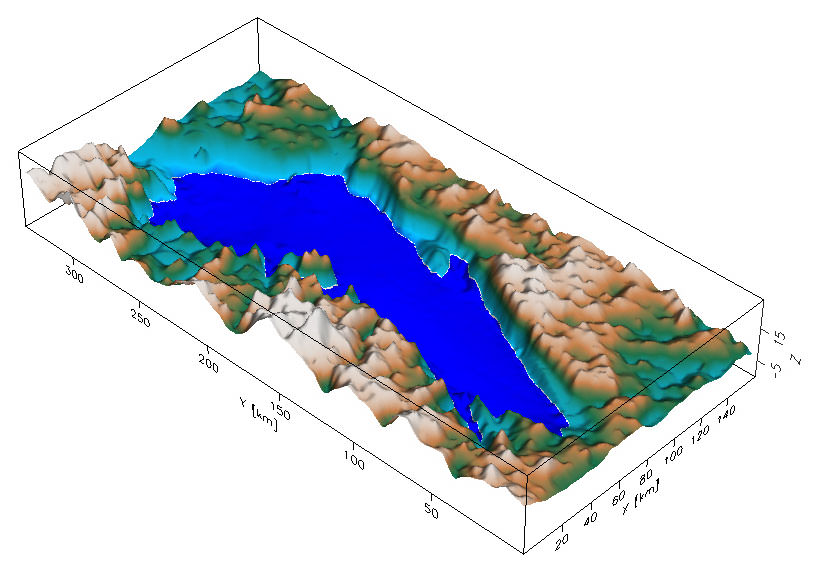
Η μεγαλύτερη από τις 140 υπόγειες λίμνες της Ανταρκτικής, στις οποίες το νερό διατηρείται περιέργως σε υγρή μορφή, η λίμνη Βοστόκ έχει μήκος 250 χιλιόμετρα και πλάτος 50 χιλιόμετρα. Είναι μια πραγματικά μεγάλη λίμνη, με το βάθος της να φτάνει σε ορισμένα σημεία τα 800 μέτρα.

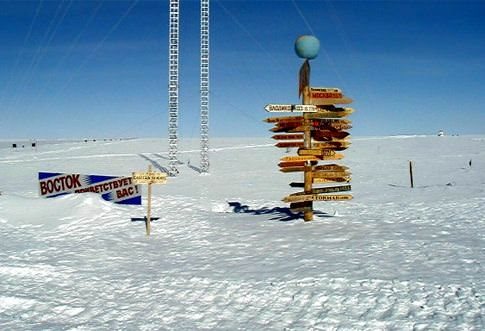
Τέσσερα χιλιόμετρα πιο πάνω, στην επιφάνεια του πάγου, βρίσκεται ο ρωσικός σταθμός Βοστόκ, όπου έχει καταγραφεί η χαμηλότερη θερμοκρασία οπουδήποτε στη Γη: -89,2 βαθμοί Κελσίου.

in.gr - Απρόσιτη παρέμεινε και φέτος η «εξωγήινη» λίμνη Βοστόκ της Ανταρκτικής - Ειδήσεις - Επιστήμη-Τεχνολογία
 

North66

Member
Μηνύματα
4.303
Likes
5.039
Επόμενο Ταξίδι
Γεωργία
Ταξίδι-Όνειρο
Γροιλανδία
Στο παρά τρίχα απέτυχε η φετινή απόπειρα Ρώσων ερευνητών να φτάσουν την υπόγεια λίμνη Βοστόκ της Ανταρκτικής, ένα από τα τελευταία ανεξερεύνητα μέρη της Γης.
Δηλαδή αν πετύχαινε η γεώτρηση θα την είχαν εξερευνήσει?
Ο συγγραφέας του άρθρου δεν μπορεί να ξεχωρίσει τις έννοιες έρευνα και εξερεύνηση.
 

nspanoud

Member
Μηνύματα
6
Likes
0
Επόμενο Ταξίδι
ΜΕΞΙΚΟ
Ταξίδι-Όνειρο
ΠΑΠΟΥΑ ΝΕΑ ΓΟΥΙΝΕΑ
Δηλαδή αν πετύχαινε η γεώτρηση θα την είχαν εξερευνήσει?
Ο συγγραφέας του άρθρου δεν μπορεί να ξεχωρίσει τις έννοιες έρευνα και εξερεύνηση.
1) Κατ' αρχήν πιστεύω ότι τέτοιου είδους σχόλια είναι περιττά και χαλάνε το καλό κλίμα μεταξύ των μελών. 2) Το άρθρο είναι από το in.gr, οπότε τα όποια σχόλια να διευκρινιστεί ότι απευθύνονται στον/ην δημοσιογράφο και όχι στη Ρόζα. 3)η γεώτρηση δεν απέτυχε, αλλά δεν ολοκληρώθηκε. 4) δεν βλέπω πουθενά να συγχέονται οι έννοιες έρευνα και εξερεύνηση.
 

North66

Member
Μηνύματα
4.303
Likes
5.039
Επόμενο Ταξίδι
Γεωργία
Ταξίδι-Όνειρο
Γροιλανδία
4) δεν βλέπω πουθενά να συγχέονται οι έννοιες έρευνα και εξερεύνηση.
Συγχέεις την έννοια εξερευνητής (τόπων, λιμνών, βουνών κτλ) που προϋποθέτει φυσική παρουσία με την έννοια ερευνητής (γεωλόγος, σεισμολόγος, γεωφυσικός κτλ) που υπονοεί εργαστηριακή ή από απόσταση έρευνα.
Aκόμα και να ολοκληρωθεί η γεώτρηση, η λίμνη θα παραμείνει ανεξερεύνητη.

Το άρθρο είναι από το in.gr, οπότε τα όποια σχόλια να διευκρινιστεί ότι απευθύνονται στον/ην δημοσιογράφο και όχι στη Ρόζα.
Στη δημοσίευσή μου αναφέρθηκα στο συγγραφέα του άρθρου. Αν ήθελα να αναφερθώ στη Rosa θα έλεγα στο συγγραφέα της δημοσίευσης.
 

maltakias

Member
Μηνύματα
2.538
Likes
3.226
Επόμενο Ταξίδι
Όπου λάχει
Ταξίδι-Όνειρο
Περού
Πάντως το άρθρο μιλάει για την πράξη (εξερεύνηση) κι όχι για το άτομο (εξερευνητής) και σύμφωνα με το λεξικό

ρ μετβ εξερευνώ [ekserev'no] ερευνώ άγνωστούς μου χώρους

Υπ'αυτο το πρίσμα,ασφαλώς και πρόκειται για εξερεύνηση.Άσε που σε καμία περίπτωση δεν μιλάμε για εργαστηριακή έρευνα.


Κοίτα τώρα θέμα που ανοίξαμε.
 

fitziano

Member
Μηνύματα
1.934
Likes
533
Επόμενο Ταξίδι
Αθήνα
Ταξίδι-Όνειρο
Νέα Ζηλανδία
Είχα πρόχειρη την Britannica. Ελπίζω να βγάλετε άκρη σε αυτό το μεγάλο ερώτημα...

exploration


the investigation of the Earth for scientific, commercial, or military purposes. By the close of the 20th century, virtually all of the Earth's surface had been explored, and attention was largely directed toward its subsurface regions and its oceans, particularly the deep ocean floor. The exploration of outer space also was a major point of interest (see also space exploration).

The deep interior of the Earth remains a major frontier, since most of the subsurface exploration so far undertaken has been limited to the Earth's uppermost crust. A large number of exploratory projects conducted today involve prospecting for deposits of metals, fossil fuels (e.g., oil, natural gas, and coal), and other commercially important minerals, as well as for recoverable groundwater, sources of geothermal energy, and sites geophysically suitable for power plants, factories, and depositories for hazardous wastes.

The methods used in exploring the Earth's subsurface (as well as its surface in many cases) are of two general types: direct and indirect. Direct methods entail drilling, excavating, and sampling. Indirect methods involve geochemical analysis and measurement and geophysical surveys of such phenomena as reflectivity, gravity, magnetism, seismic waves, and heat flow. The indirect approach often begins with radar mapping from aircraft and photographic surveying from Earthorbiting satellites equipped with opticalmechanical infrared scanners and multispectral scanners. This form of remote sensing can reveal groundwater movement, hydrothermal areas, and specific types of subcropping rocks associated with mineral concentrations. Geophysical measurements are widely used in the search for oil and minerals and in building-foundation investigations. Geochemical prospecting techniques are commonly employed to measure trace contents of certain elements in rock, water, vegetation, and other surface materials that may indicate the presence of a buried body of ore in a given area.

Direct sampling, generally by means of boreholes, is often required to make positive identification of substances and to determine the quantity, as well as to choose appropriate methods of recovery. Drilling and other techniques of direct exploration are of somewhat less significance in the scientific study of the deep Earth, because of high cost and the limited depth attainable. To date, the deepest borehole drilled extends about 12 km (7.5 miles) into the upper crust. As a consequence, scientific investigators have to rely heavily on geophysical measurements, particularly of seismic waves associated with earthquakes, to secure information about the Earth's interior and its dynamic processes. During the early 1980s seismic investigations of the Appalachian Mountain region of the United States, for example, resulted in important discoveries about continent formation.

The practical value of ocean exploration has long been established by those countries that exploit the sea's natural resources, transport goods and people across its surface, or maintain their national security by controlling its lanes. Scientific investigation of the ocean, which includes the study of the physical and chemical properties of seawater, all forms of marine life, and the geologic and geophysical features of the ocean floor, has also proved beneficial. Studies of the interaction of the ocean and the atmosphere have enabled scientists to predict more accurately long-term climatic and weather variations. Moreover, undersea exploration of the seafloor and its gravitational and magnetic properties contributed much to the development and widespread acceptance of plate tectonics, a concept that has not only revolutionized scientific understanding of the Earth's dynamic features but has led to the discovery of rich deposits of valuable metals on the ocean bottom as well. Exploration of the oceanic depths also has resulted in the discovery of previously unknown forms of marine life and made it possible to determine the distribution of diverse fish populations.

Scientific study of the ocean involves the collection of data on ocean currents (surface and bottom), seawater temperature and salinity, marine life, and the topography of the ocean floor. Most exploratory work is carried out from a moving or stationary surface ship. Such a research vessel must be sturdy, stable, and capable of carrying oceanographic winches and various measuring and sampling devices; it must also have adequate deck working space, laboratory facilities, cruising range, and living accommodations for scientists and crew.

One geophysics research program, known as JOIDES (Joint Oceanographic Institutions for Deep Earth Sampling), operates Resolution, a deep-sea drilling vessel that represents a major advance in research ships. It is equipped with a computer-controlled dynamic positioning system, which allows it to remain fixed over a specific site while drilling to depths as great as 8,300 m (27,200 feet). The vessel can also collect cores of sediment and underlying igneous rock from the deepest points of the seafloor.

Submersibles, which allow direct and detailed observation at various depths, are widely used for undersea exploration. In 1960 a record manned descent to the Mariana Trench reached 10,740 m (35,240 feet) below sea level.

Unmanned instrument platforms such as buoys are employed in seismic experiments, which are useful in determining the structure and thickness of the Earth's crust beneath the seafloor. Seismic experiments involve the measurement of the rate of propagation of sonic energy from any of several sources to a series of pressure detectors suspended from the buoys. The measurements are made at depths below the influence of wave action.

Remote sensing has become an increasingly important means of exploring the ocean because it can provide a sweeping view of the ocean. High-resolution, thermal-infrared data from polar-orbiting satellites, for example, are used to track wave features in currents. In another technique, radar altimeters aboard satellites are utilized to measure sea-surface topography.
 

Spyros-007

Member
Μηνύματα
756
Likes
1.815
Επόμενο Ταξίδι
Δεν ξέρω ...
Ταξίδι-Όνειρο
Ταϊλανδη κα ξανά Ταϊλάνδη
Tώρα μάλιστα! Το κατάλαβα!
 

orestcrete

Member
Μηνύματα
2.607
Likes
9.864
Επόμενο Ταξίδι
Iceland
Ταξίδι-Όνειρο
New Zealand
το φαινομενο οτι υπαρχει νερο εκει κατω,ενω λιγο πιο πανω εχουνε καταγραφει οι χαμηλοτερες θερμοκρασιες στην Γη,πως το εξηγουνε;;;;
 

ΕΡΣΗ

Member
Μηνύματα
6.454
Likes
2.531
Επόμενο Ταξίδι
Βερολίνο (ξανά!)
Ταξίδι-Όνειρο
Λάος, Βιετνάμ, Καμπότζη
Υποθετω οτι σε τετοιο βαθος θα υπαρχει αλλη ατμοσφαιρικη πιεση απο αυτην της επιφανειας.
 
Μηνύματα
1.666
Likes
1.327
Επόμενο Ταξίδι
Κρακοβία-Βαρσοβία
Ταξίδι-Όνειρο
...Ιθάκη...
Τώρα που ξαναείδαμε το δάσος και σταματήσαμε να κοιτάμε το δάκτυλο, μπορώ και εγώ να δηλώσω ότι η είδηση της ύπαρξης μιας λίμνης σε ένα τόσο απίθανο μέρος με άφησε κατάπληκτη.
 

Εκπομπές Travelstories

Τελευταίες δημοσιεύσεις

Booking.com

Ενεργά Μέλη

Στατιστικά φόρουμ

Θέματα
33.219
Μηνύματα
884.061
Μέλη
38.910
Νεότερο μέλος
giota789

Κοινοποιήστε αυτή τη σελίδα

Top Bottom